Since a large part of The Netherlands lies below sealevel,
you can imagine that there is quite some flooding
and fighting against the water!
 |
the Province of ZEELAND the DELTA area south of HOLLAND in The Netherlands. |
|
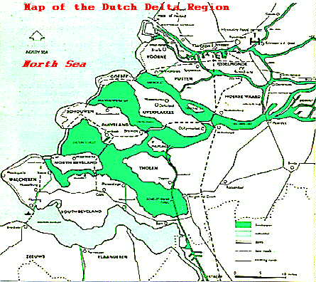
This is a map of the DELTA which is at the mouth of three major rivers one of which is the RHINE, coming in from the East (=right). You see a dozen or so islands surrounded by water (green). Separating each island from the water is a DIKE You also see a set of structures between the fresh water (green] and the North Sea (at the left]; each of these is a DAM. So, to summarize: DIKES are along |
|
The next page will show a cross-section ot the situation,
which represents another way of looking at things than a map.
(like at 90 degrees vertical]
| to return to previous page |

| BLO 990119 |